
Junction Triangle Railway Railpath

The Junction Triangle’s Early Years
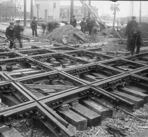
A crew working on the railway diamond crossings, West Toronto, 1924. Image: City of Toronto Archives
West Toronto Station, Canadian Pacific Railway, Old Weston Road, e. side, n. of Dundas St., Toronto, 1952. Photo by James V. Salmon. Courtesy of the Toronto Public Library.
Intersecting railway lines that form the “triangle”, Atlas of the City of Toronto and Vicinity by Charles. E. Goad, 2nd Edition, Plate 45, March 1890. Source: Toronto Public Library
West Toronto Railpath, Junction Triangle, Toronto, April 5, 2021.
Naming the neighbourhood
The dynamic neighbourhood known today as the Junction Triangle has been one defined by movement — of goods, services, and people — for almost 14,000 years. Situated on a natural escarpment, the area once contained vital trade routes for the Wendat, Haudenosaunee, and Mississaugas of the Credit River First Nations, as well as early settlers. In the nineteenth century, after generations of use, one of these traditional trade routes became the basis for the Georgetown Rail Corridor that now lines the Junction Triangle neighbourhood’s western border.
Over its many years of use, the neighbourhood has been known by many different names, including Perth Park and the Rail District. The first reference to the area as the “Junction Triangle” dates to the 1970s, a reference to the triangle shape of the neighbourhood bordered by railway tracks. But only in 2009 did a local community group, known as the Fuzzy Boundaries naming project, spearhead a formal process for the local community to select its own name. After 230 suggestions and over 670 votes, the name “Junction Triangle” was formally adopted in 2010. In the years following, developers began to see the tremendous potential of the neighbourhood.
Laying the tracks
The Ontario, Simcoe, and Huron Railway laid the first track in what would become the Junction Triangle in 1853. In the three decades following, further railway construction was undertaken in the area by the Grand Trunk Railway Co.; the Toronto, Grey and Bruce Railway; the Canadian Pacific Railway; the Credit Valley Railway; and the Ontario and Quebec Railway. By 1883, the “triangle” of intersecting railway lines was fully established.
By 1888, the Junction Triangle neighbourhood was growing quickly, largely thanks to the contributions of Simeon Janes (d. 1907). Janes, already known for his development of Toronto’s Annex neighbourhood, bought cheap land in the West Toronto area during the depression of 1879. On this land, Janes built houses, churches, schools, and other community infrastructure, helping to shape the West Toronto area, and particularly the Junction Triangle community, in its early years. Within a few decades, tenancy in the area had increased significantly, and the neighbourhood went from being a quick stop on a rail journey, to an industrial hub and bustling residential hot spot.
An emerging community
In the early 1900s, immigrants began flocking to the Junction Triangle. It became one of the two most popular destinations for immigrants settling in Toronto at the time — the other being St. John’s Ward in the downtown core. Large groups of Ukrainian, Macedonian, Italian, Polish, and Portuguese families moved to the Junction Triangle in search of work. With factories appearing on seemingly every corner, the Junction Triangle had plenty to offer. Newly arrived residents found jobs in feed yards, planing mills, and manufacturing plants. Alongside a growth in population, the neighbourhood became a part of ever-growing urban infrastructure, becoming a part of the City of Toronto in the late nineteenth century.
The West Toronto Railpath
Today, many of the former railways that once defined the Junction Triangle have been reimagined to serve new and modern uses. Though officially opened in 2009, the West Toronto Railpath follows a travel route that has been used for over a century. In 1998, the City of Toronto was looking for new cycling trail opportunities. Influenced by the popular American “Rails to Trails” movement, a last-minute suggestion was made for the City to consider the Junction Triangle railways as a potential trail location. It was proposed that the Toronto-Georgetown rail corridor, originally used by the Toronto, Grey and Bruce Railway Company, be considered for redevelopment into a walking and cycling path. This railway route was built in 1860, and was the first side of the Junction Triangle’s “triangle” to be built. In 2009, the Railpath, running from Cariboo Avenue north of Dupont Street to Dundas Street West, was officially opened. Today, the Railpath serves as a reminder of the significant role the railways played in the development of the Junction Triangle community.