
St. Lawrence Market

Tkaraonto
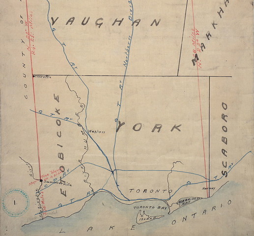
Original plan of the Toronto Purchase (1787-1805), outlined in red ink, 1911. Image: Toronto Public Library
St. Lawrence Market. North Market (1850-1904), Front Street East, north side, between Market & Jarvis Streets, prior to 1898. Toronto Public Library.
William Davies Stall, St. Lawrence Market, 1911
Tkaraonto
The land that this tour takes place on is the traditional territory of many nations. Indigenous peoples and European settlers used this area to trade and exchange goods long before the current St. Lawrence Market building was built. The name “Toronto” comes from the Mohawk word Tkaronto (tga-roon-doe), referring to the fishing weirs in Lake Simcoe, but European settlers mistook it for the meeting place that became Toronto.
The Toronto Purchase
In 1787, British settlers prepared a written agreement, called the Toronto Purchase, in order to claim the land used by the Mississaugas. The British and Mississaugas had different understandings of land ownership: the Mississaugas believed they were allowing the British access to their land, while still retaining their traditional rights.
The First Market
The British saw the land as firmly under their control, and began to build a city for themselves, pushing the Mississaugas out. In 1803, the portion of land on which the St. Lawrence Hall now sits was designated as a public market space. The first market building, marked by the yellow brick on the exterior, included the City Council chambers.
Hogtown
In the 1850s, William Davies arrived in Canada and set up a stall where he sold a cut of pork that would become a signature food at the market: peameal bacon. He expanded his business to become one of the largest of its type in the British Empire, contributing to Toronto’s nickname of “Hogtown.”