
Scarborough Indigenous First Nations

Indigenous Roots
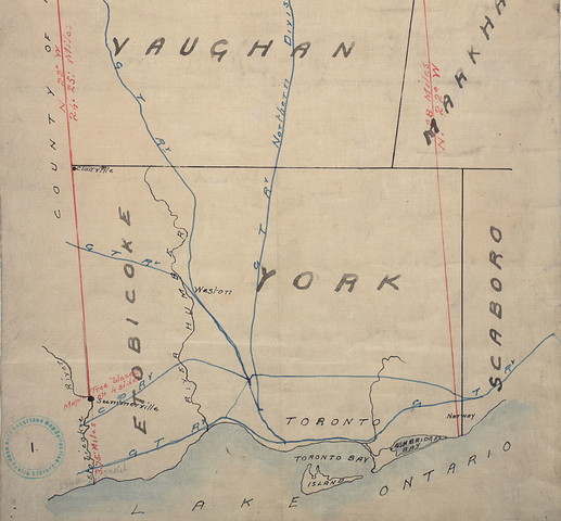
Original plan of the Toronto Purchase (1787-1805), outlined in red ink, 1911. Image: Toronto Public Library
Page 2 of the Williams Treaty with the Mississauga Indians of Rice, Mud and Scugog Lakes and Alderville, November 15, 1923. Image: Library and Archives Canada
Indigenous Roots
Historian Barbara Myrvold explains at the beginning of her book, The People of Scarborough: A history (1997), that “For over 10,000 years, humans have occupied the area that is now known as Scarborough. And for more than 97% of that time, the First Nations were in sole possession of the region.” We know from archaeological digs, oral histories, and from European Settler accounts that First Nations, including the Mississaugas, Seneca, Haudenosaunee, and the Wendat, used Scarborough’s land for portages and travel, trade, hunting, and living. They set-up temporary camps, and more permanent agricultural settlements, notably near the Rouge River, and to the northeast in what we now know as Highland Creek.
Scarborough is not a First Nations name – the closest Indigenous name being “Chi Sippi” for the Rouge River, which means Large Creek in Anishnaabemowin. Instead, the area owes its name to Elizabeth Simcoe, wife of the Governor of Upper Canada, who while riding on horseback through the Scarborough bluffs in the late-eighteenth century, was reminded of the cliffs of Scarborough in England.
The Gunshot Treaty
Scarborough’s land is said to have been ceded by Anishnaabe Peoples to the British crown in the Gunshot Treaty of 1788. “Gunshot” seemed an appropriate name; the story goes that land was surrendered as far north from the water as a gunshot could be heard and as far east as the Bay of Quinte, starting from the borderline of lands ceded in the Toronto Purchase of 1787. However, while the British government operated as though Scarborough lands were in their possession, only limited and incomplete paperwork could be found to support these claims.
The Williams Treaties
Scarborough was not included in the original Toronto Purchase, nor was it included when the treaty was revised in 1805. There had been settlers in the area since the 19th century and the Mississaugas and Chippewas of the area were concerned with how these settlements affected their land rights. The Mississauga and Chippewa chiefs were most concerned with their hunting, fishing and gathering rights and came to believe that these would be secured with the signing of the treaties. They tried to meet with the government concerning this land, and were only successful after 60+ years of effort.
The land was eventually ceded as part of the Williams Treaties of 1923 which collectively involved almost 13,000 acres of land. The terms were set by the Ontario and Canadian governments, and it involved a one-time payment to each participating First Nation, which included the Chippewas of Beausoleil, Georgina Island and Rama, the Mississaugas of Alderville, Curve Lake, Hiawatha, and Scugog Island. This payment was around $200,000, or approximately $3 million today, plus small one-time stipends to individual band members.
Scarborough’s Indigenous Roots
Harvesting rights that the Mississaugas and Chippewas thought were protected under the agreement, in fact, were not. They were prosecuted for hunting, fishing or gathering on Williams Treaties land. The land designated to them for reservations was small and did not include much of the area they had traditionally used for cultivating crops.
Continued dispute and reconciliation
In September 2018, the Canadian government issued an apology for the treaties and how they were handled. The negotiated settlement that accompanied the apology included financial compensation, a recognition of harvesting and land rights, and additional reserve lands. This action was a result of the Alderville litigation first brought forth by seven First Nations of the Williams Treaties in 1992.
The land continues to be contested by the Mississaugas of New Credit, as they were not signatories of the Williams Treaties, and therefore never ceded the land. In 2015, they submitted a claim to the federal government for the land, known as the Rouge Tract, to be returned to them.